Address by Danene van der Westhuyzen – OPENING HUAP TRUST RHINO FUNDRAISER2017
December 5, 2017
Zebra Hunting in the Khomas Hochland
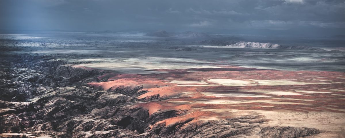
November 20, 2018Namibia is a harsh country; at times its nature even appears unfriendly. This photo by photographer Paul van Schalkwyk, taken from his Cessna 206, which he himself flew while taking his spectacular shots, gives insight into its grandiose uniqueness – one is almost inclined to say it is the perspective from which the Creator saw the country and how he wanted it.
Photos ©Paul van Schalkwyk
Gabi Schneider
N amibian landscapes are like a wide-open story book giving deep insight into millions of years of geological history. This dramatic photo by the late Paul van Schalkwyk shows a canyon which the ephemeral Kuiseb River, with its source in the highlands around Windhoek, has eroded into the Namib peneplain some five million years ago. In places, the canyon is up to 200 m deep, and it has a network of tributaries forming a wild, dissected terrain often referred to as “grammadulas”.
The Kuiseb drainage is the most prominent watercourse in the central-western region of Namibia and forms the spectacular northern boundary of most of the main Namib Sand Sea World Heritage Site.
Long before the Kuiseb River, sediments were deposited in an ancient ocean in this area, and these sediments are today represented by the vast schists (seen on the left side of the picture), called the Kuiseb Formation by geologists. The beige rocks capping the schists are sandstones of the Tsondab Formation, which is a precursor of the modern Namib, and conglomerates of the Karpfenkliff Formation deposited by an early Kuiseb River before it started to deeply incise its bed all the way down to the schists some 10 to 20 million years ago. The boundary between the younger sediments and the schist embodies more than 700 million years of Earth’s history!
The current red dunes of the Namib Sand Sea represent the youngest geological feature and show the continuous nature of geological processes, as their sand is blown into the canyon by south-westerly winds, only to be washed out by the next ephemeral flood.
It was in this harsh and unforgiving landscape that German geologists Henno Martin and Herman Korn took refuge for more than two years during World War II. Their sojourn is described in the book The Sheltering Desert.
This article was first published in HuntiNamibia 2018.


